3DD Version 3.1
Pre-release Description
About This Document
This document is intended for existing users of 3DD 3.0. It details the advantages of upgrading from 3DD 3.0 to 3DD 3.1, which is a free upgrade to all 3DD 3.0 customers with current 3DD ADAMcare maintenance contracts.
What’s new in 3DD 3.1?
Large Job support
The most obvious improvement for many users will be the elimination of the memory problems many experienced with 3DD 3.0. 3DD 3.1 has been rewritten to run in Protected Mode, a special mode on Intel 80286 and later CPUs that allows DOS programs to access up to 16MB of memory. Because of this, the limitations on job sizes — the number of strips, models, and control points allowed in a job — have been effectively removed. It will no longer be necessary to split a large project up into multiple jobs in order to work within the 640K DOS memory limitations.
ADAM ORTHO System 2.0 support
3DD 3.1 adds some important new features when combined with the new ADAM ORTHO System 2.0.
- Vector data can be superimposed on an ortho image for completeness and accuracy checking. Simply scan the model area and save the image in your 3DD 3.1 job directory, then overlay your vector data on it by choosing User Operations/Map Compilation/Overlay MAP files on Ortho.
- A sheet file created in 3DD can now also be printed as an overlay on top of an orthophoto. The sheet file is symbolised as usual in 3DD and then exported using the new User Operations/Plotting/View Sheet in OrthoView menu item. This also allows any Windows-supported printer to be used for plotting 3DD sheet files.
Aerosys Bundle Adjustment support
Using Aerosys for aerotriangulation is now supported directly via the 3DD 3.1 menus (Figure 1). Two options are available, depending on the level of control you want to have over the bundle adjustment.
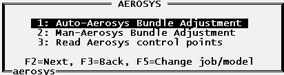
Automatic Aerosys Bundle Adjustment
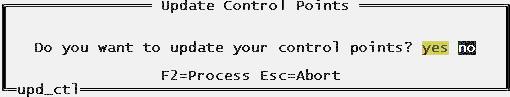
You can perform a fully automatic bundle adjustment by selecting the User Operations/Orientation Data Transfers/Aerosys/Auto-Aerosys Bundle Adjustment menu. 3DD will automatically generate all the required data and then launch Aerosys to calculate ground co-ordinates for those points. Once complete, you can choose whether you want to accept the control point results that Aerosys has computed. If you choose ‘yes’ at the Update Control Points popup window, 3DD will store the computed ground control points in the job’s control point list for you.
Manual Aerosys Bundle Adjustment
For more control over the bundle adjustment, you can select the User Operations/Orientation Data Transfers/Aerosys/Man-Aerosys Bundle Adjustment menu instead. The process of computing the bundle adjustment is exactly the same as the Auto-Aerosys Bundle Adjustment menu described above, except that this option allows you to examine the results of every step while computing the bundle adjustment.
3DDView
3DDView is a new program supplied with 3DD that allows Windows users to plot sheets to any Windows-supported plotter. Selecting User Operations/Plotting/View Sheet in 3DDView from the menus will display the current sheet file for inspection and printing. 3DDView is very similar to the new ORTHO 2.0 OrthoView program, except it does not have the ability to show an image in the background.
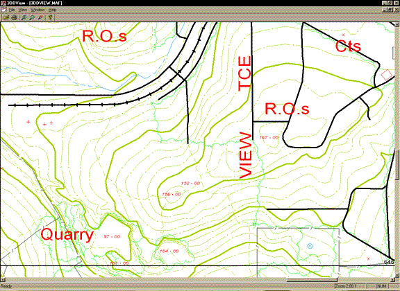
Figure 3. Viewing a Symbolised Sheet File with 3DDView
Windows font support
A key feature of 3DDView is the ability to substitute native Windows fonts for existing 3DD ones. The Font Settings dialog (Figure 4) is reached through the View/Font Settings menu.
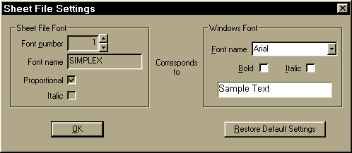
Using this dialog, you can select which Windows font you wish to map a given 3DD font to. The properties of the selected 3DD font are shown on the left for reference to aid in the selection of an appropriate Windows font.
Other Changes
There are a large number of smaller improvements that have been introduced in 3DD 3.1, many in response to customer requests. Here is a selection:
- TRAN now records transformation information in the job’s log file like OBSERVE does, in order to help setting up a model a second time.
- TRAN now allows points to be added, deleted, and renamed during transformation like OBSERVE does.
- Added support for multiple digitising devices to the MAPMACRO file like 3DD 2.2 used to have. In 3DD 3.0, only one digitising device definition was supported.
- Added new menus Join groups of MAP files and Append MAP file under Supervisor File Maintenance/Join MAP files. The former allows all files starting with a given pattern to be combined into a single file, while the latter allows a single file to be appended to the current one.
- Added the ability for the user to change the current snap mode using a hotkey rather than pressing F2 to visit the Edit Status window.
- The number of characters allowed on a line in an MVE file has been increased. This required the updating of the question type to allow it to scroll when the length of the contents was greater than the length of the text entry area onscreen. Support for all the usual keys (arrow keys, etc) was also added.
- Added support for point entities in DXF files when importing.
- Added the ability to revert to the previous view after a zoom in, zoom out, window, or home operation in JIM by pressing Alt+w.
- JIM no longer reports an error when the user edits a 2D or Fixed RL feature. The error was harmless, but annoying.
- JIM now adds a vertical offset to 3D parallel features, so it becomes a full 3D offset rather than just a 2D one.
- Added support for Windows 2000.
- Increased the number of MAP files that can be overlaid in JIM to eight. This allows the user to specify overlays all around the current MAP file.
- Added the ability to convert 3DD 2.2 sheet files into 3DD 3.0 format. This is mainly useful to those who have title blocks in .SHT format with missing .MVE files, or who have extensively edited the title blocks after they were initially created from an .MVE file.
- SHEETS now generates standard sheet boundaries for Cartesian co-ordinate systems with more points along the edges to improve the accuracy. The deviation from the "true" boundary should be no more than 0.01m now.
- UPD_SHT now calculates standard sheet boundaries much more accurately than before. The accuracy is now determined solely by the distance to the false origin, meaning accuracies of 0.1m are achievable as long as the false origin is not too far away.
- TRIM now trims features to polygons specified in ASCII text files much more accurately. This is particularly noticeable to users who trim MAP data to standard sheet boundaries.
- Added an extra commandline parameter to SYMBOLM so a report file can be specified. Duplicate points and the features they occurred in are now recorded in the report file rather than causing an error message window to pop up, which could become annoying.
- Changed the parameters used to create the Edit Station menus so that the Cameras and Lenses and Orientation Data Transfers menus are available.
- Changed ITNDRAPE so it no longer has problems if the supplied DTM does not completely cover the area being draped. Features that lie outside of the DTM will not be affected by the draping.
- Increased the plate size limit for photo scanning from 230mm square to 250mm square. This makes it easier to scan 230mm diapositives as they no longer have to be centred on the plate to reach all fiducials.
- Added a new Fixed RL height digitising feature to JIM. This allows the height of a Fixed RL feature to be digitised without having the digitised point included in the final feature, allowing the bounding box of rooftops to be easily digitised for use in GIS packages, for example. To use the feature, press Ctrl+h after pressing f to start a Fixed RL feature, then digitise a point with the height to be used for the whole feature.
- Added support for wildcards when specifying MAP file names in JIM’s initial startup window.
- Added support for using F1 to bring up a list of MAP or SHT files in the current directory in JIM’s initial startup window.
- Features digitised as symbols are now plotted relative to the ground’s orientation and not the sheet’s orientation. This is a reversal of a change made in 3DD 3.0c. The correct method to create symbols that maintain the same orientation with respect to the sheet is to digitise them as point features and then define the appropriate symbol in the plot style.
- Text features are now transferred to the output file when INTSECT is run.
In addition to these improvements, the following problems have also been addressed:
- Fixed a problem with the mouse in JIM when VESA display modes were used.
- Fixed a bug in PREPARE that would cause it to crash if a point was later added to a model that was originally created without any points in it.
- Fixed problem with JIM crashing when "Hide" was used while digitising a feature.
- JIM now displays the correct heights for spot heights. The false origin wasn’t being added to the value previously.
- Fixed display problem in OBSERVE where the residuals were not scrolled up with the names when a point was inserted on the last row of the screen.
- Fixed problem in OBSERVE where the ground residuals for a point would not show if you inserted it and changed its name to an existing ground control point while doing the exterior orientation.
- Changed UPD_CAM to protected mode to prevent it from running out of memory on some PCs.
- Fixed a bug that caused the letter "o" to be placed before the question for the data path during installation if an existing installation was detected.
- Fixed the stack overflow bug in MAP that occurred when F1 was pressed in various locations, such as the ITN Processing/Contour Processing/Smooth contours question, among others.
- Fixed a bug that would cause REORG to crash and DUMP to hang if there was a feature in a MAP file with an illegal type.
- PREPARE now ensures that the spheroid associated with a chosen horizontal co-ordinate system is copied into the job header. SHEETS, which produces standard sheet boundaries, depended on it being there.
- Fixed a bug that caused SYMBOLM to hang if a template using shading was encountered during symbolisation.
- Fixed the problem JIM was having with certain combinations of fonts (e.g. SIMPLEX non-proportional).
- Fixed a bug in MK_SHEET that meant that the first font specified in the .MVE file was always assumed to be proportional regardless of the specification.
- Fixed problem with continuous digitising using a Mimaka-equipped analogue system. Previously only the point where the footswitch was depressed and the point where the footswitch was released would be digitised, with a straight line connecting the two points.
- The message files for MM2AS and AS2MM are now named correctly. Spurious error messages were appearing when generating AS2482 files because the wrong message file was being read.
- Fixed crashes that sometimes occurred when importing control points using PREPARE.
- Fixed problem that sometimes caused GROUP (part of Polygon’s intersection processing) to report an "Out of Memory" error, even though it reported allocating far less than was actually available.
- Fixed problem with Polygons, where duplicate polygon annotations would be generated at two different sizes for each polygon.